Eighty years ago (in the 1930's) the Ordnance Survey set out to accurately measure the whole of Great Britain. They did this by placing a network of concrete pillars (triangulation points) at strategic spots, usually hill tops, and then calculating distances between them by using trigonometry. You can read more about the early history of the Ordnance Survey.
The purpose of this site is to catalogue our visits to individual trig pillars around Great Britain so that they can be reunited, at least in print! It is the result of our personal "bagging" of Trig Pillars that started after purchasing a GPS machine to record the position of Redwood Trees in the UK
Although most of the trig pillars are now redundant, many of them are still standing and some enthusiasts enjoy "spotting" these, much in the same way as one might train spot!
Warning - it can be addictive, especially if you travel with others whose idea of fun is to run up to the pillar at the last minute and 'bag' it by being the first to actually touch it, even when you have been doing all the hard work tracking the co-ordinates with a GPS machine.
Trig Hunting: A harmless bit of fun and a great excuse for getting out and about in the countryside.
|
|
Locations and Photographs |
S1460
S1878
S2053
S2056
S2136
S2179
S3121
S3349
S3444
S3445
S3462
S3846
S3851
S3857
S3867
S3868
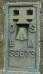
S3873
S3894
S4032
S4033
S4082
S4083
S4114
S4507
S4510
S4543
S4762
S4764
S4765
S6763
S6773
C1SP8001
C1TL8517
C1TQ9284
|
Muswell Hill - B4011, Thame
Hawksberry Manor - Hawksburybush Lane, Basildon
Cock Road - Maplestead
Gallows Hill - Thetford
Wangford Warren - Thetford Forest
Oswestry
Dog Kennel Hill - Hainault Country Park
Great Fanton Hall - A127, Basildon
Nobles Green - Green Lane, Eastwood
Lovedown - Lower Road, Hockley
Priors Farm - Hollow Lane, Chelmsford
Beacon Hill -
New Barn - , Tiptree?
Iltney Farm, New Hall Lane, nr Maldon
Mascalls - West Hanningfield Road, Chelmsford
East Hanningfield - Southend Road, East Hanningfield
Erringham Hill - Mill Hill, Brighton
Court Farm W Blatchington - Devils Dyke Road, Brighton
Devils Dyke - Devils Dyke Road, Brighton
Brickbarns - Mashbury Lane, Chelmsford
Upper Edwards Hall - Bosworth Avenue, Eastwood
Truleigh Hill - South Downs Way, Brighton
Atkins Farm - Nairdwood Lane, Great Missenden
Potters Crouch - Blunts Lane, St Albans
Great Easton - Snow Hill
Mill Hill - Springhill Road?, Edgcott
Brill House - Thame Road, Brill
Moreton Farm - Water Lane, Aylesbury
Stoke Lyne - Stratton Lane, Stoke Lyne
Heet Farm - off A41, Blackthorn
Wardrobes - Upper Icknield Way, Princes Risborough
Crabb's Farm - Kelvedon
Shoebury Common - Shoebury Common Road, Shoebury
|
Links
Ordnance Survey free GPS and positioning services
Ordnance Survey Passive Station Database Search
TrigTools.co.uk
GPS Waypoints - Trigpoints
Trigpointinguk.com
United Kingdom Trig Points
Search for trig points
GPS Visualizer - covert your GPS data for use in Google Earth
Geocaching... coming soon!
|
The bonus for trig hunters is the fantastic views across the English countryside, as most of these pillars were erected in high places in sight of other pillars miles away.
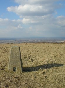
Example Trig Pillar |
Example view from top |
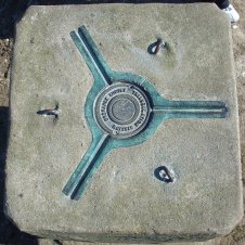
Example Flush bracket |
|
|